Papio NRD Names New Reservoirs & Recreation Areas

The Papio NRD Board of Directors has named four of its upcoming flood reduction reservoirs and recreation areas that will be located in the Omaha metro.

Mad Bear flood reduction reservoir under construction near 168th & Giles Road in Gretna.

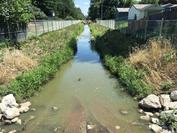
The projects will feature no-wake lakes (reservoirs) and recreation amenities, including trails, kayak/canoe launches, fishing access, and picnic areas.

The names include:

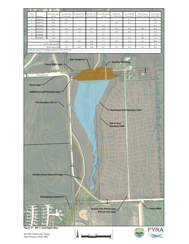
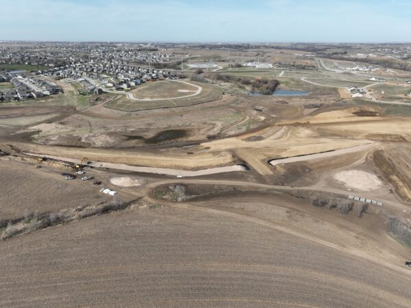
  • Marlin Petermann Recreation Area – under construction near 180th and Fort Street in Omaha. Estimated to be complete spring of 2027.
  • Mad Bear Recreation Area – under construction near 168th and Giles Road in Gretna. Estimated to be complete fall of 2025.
  • Forest City Recreation Area – under construction near 204th and Schram Road in Gretna. Estimated to be complete late summer of 2025.
  • Dr. Susan La Flesche Picotte Recreation Area – to be located near 192nd and Giles Road in Gretna. Construction estimated to begin in five years.

“As a veteran of the United States Army, I felt strongly that one of the new flood reduction reservoirs and recreation areas be named after the first Native American to be awarded the Congressional Medal of Honor: Sergeant Mad Bear,” said Papio NRD Board vice chairman, Dr. Larry Bradley. “Sgt. Mad Bear performed some of his meritorious duties in Nebraska. As I was raised by Oglala Lakota and am part Native American myself, naming these sites to honor notable, local Indigenous peoples is an important and meaningful tribute. In addition, recognizing the late Marlin Petermann is richly deserved, as his work at the Papio NRD directly enabled the construction of these (and many other) reservoirs and the naming of them possible,” said Dr. Bradley.

“I am honored to participate in the naming of two flood mitigation reservoirs and recreation sites after historic Native Americans that made a significant difference in Nebraska,” said Papio NRD Board Director, Jim Thompson. “These truly deserving individuals will be recognized by current and future generations who utilize these sites. Naming another reservoir and recreation area after the late Marlin Petermann is a most appropriate recognition due to his lifelong dedication and service to Nebraska’s natural resources,” said Thompson.

In response to public input for name recommendations, the board named the fourth Papio NRD reservoir and recreation area Forest City Recreation Area due to its historical significance to the City of Gretna. The name recognizes the area’s history, as the town was originally known as Forest City before the railroad’s arrival shifted development to present-day Gretna.


Papio NRD Proposes Names for Dam Sites & Rec Areas

WP-2 flood reduction reservoir under construction near 168th & Giles Road in Gretna.

The Papio NRD Board of Directors is proposing names for its four new flood reduction reservoirs and recreation areas.

The projects will feature no-wake lakes and recreation amenities, including trails, kayak/canoe launches, fishing access, and picnic areas.

The proposed names include:

  • Marlin Petermann Recreation Area (currently referred to as WP-1) under construction near 180th and Fort Street in Omaha.
  • Mad Bear Recreation Area (currently referred to as WP-2) under construction near 168th and Giles Road in Gretna.
  • Pîtarîsâru’ Recreation Area (currently referred to as WP-4) under construction near 204th and Schram Road in Gretna.
  • Susan La Flesche Picotte Recreation Area (currently referred to as DS-19) to be located near 192nd and Giles Road in Gretna.

Officials from the City of Gretna, Sarpy County, City of Omaha, as well as the general public, are welcome to submit name recommendations prior to the board meeting on March 13th at 4:00 p.m.

Those wanting to submit a proposed name can do so by sending a letter to the Papio NRD at 8901 S. 154th Street, Omaha, NE 68138, or by emailing us at papadmin@papionrd.org.


Residents in Eastern NE to See Increased Environmental & Safety Benefits

Papillion Creek Watershed Project
Improvement Plan Approved

Plan to provide environmental and safety benefits to eastern Nebraska communities


LINCOLN, Nebraska – In August 2024, the U.S. Department of Agriculture’s Nebraska Natural Resources Conservation Service (NRCS), in partnership with the Papio-Missouri River Natural Resources District (Papio NRD), received official approval on the Papillion Creek Watershed Project Improvement Plan. The plan, an extension of an effort that began in 1966, promises to deliver significant environmental and safety benefits to residents across Washington, Douglas, and Sarpy counties.

From left, Papio NRD General Manager John Winkler, NRCS State Conservationist Robert Lawson, and Papio NRD Director Patrick Bonnett.

The original planning effort led to the construction of 30 grade control structures, which have been instrumental in reducing flooding and stream channel erosion within the watershed. Building on this foundation, a local group, the Papillion Creek Watershed Partnership (PCWP), was formed in 2001 to identify future projects to further protect and enhance the watershed.

In 2019, the Papio NRD utilized the NRCS Watershed Protection and Flood Prevention Operations (WFPO) program, which has been critical in advancing the latest supplemental plan, which identifies 40 new watershed protection projects aimed at stabilizing degrading streams, reducing erosion and sediment, mitigating flood damage, and improving public safety.

NRCS contributed $560,000 toward the completion of the plan, enabling the Papio NRD to qualify for additional NRCS financial assistance for developing detailed project designs, anticipated to begin in 2025.

“NRCS is proud to provide both technical and financial support to the Papio-Missouri River NRD,” said Nebraska State Conservationist Rob Lawson. “Our top priority is to help local sponsors identify and complete watershed projects that enhance natural resources and ensure public safety.”

The Papillion Creek Watershed, spanning 245,800 acres in eastern Nebraska, includes a large portion of Omaha and the surrounding communities of Papillion, Elkhorn, Millard, and Ralston. The projects outlined in the Supplemental Plan are designed to address the pressing environmental challenges faced by these rapidly growing areas.

“The Papio NRD appreciates our strong working relationship and strategic partnership with the NRCS,” said Papio NRD General Manager John Winkler. “This is just one more textbook example of how partnerships maximize public safety and the wise management of our natural resources while simultaneously reducing the reliance on local property taxes and other scarce local resources. Nebraska has the very best natural resource management system in the country, and arguably the world, and this type of project makes us that much better,” said Winkler.

The Natural Resources Conservation Service’s Watershed Protection and Flood Prevention Operations (WFPO) program provides technical and financial assistance to states, local governments and tribes to plan and implement authorized project plans for completing numerous watershed enhancements.

Papio NRD Crews Busy Assessing Flood Damage

Papio NRD crews are busy assessing the District’s levees, structures, and parks and trails for damage after Tuesday’s flooding in the Omaha metro.

While the water along the Papio Creek near 72nd & Q Street has receded, the amount of tree debris is surreal, as is the case in many other locations.

Papio NRD General Manger John Winkler says once the assessment is complete, repairs and storm cleanup will take place as quickly as possible in coordination with municipalities and various agencies.

While Tuesday’s flooding may have been a shock, Winkler says it wasn’t to the Papio NRD team. He says the Papio NRD’s system of flood mitigation reservoirs and levees built over the last 50 years were built for events like Tuesday’s and the infrastructure worked exactly as designed. When Mother Nature is in charge, Winkler says, nothing we build can be 100%.

Please know we understand this is a very trying and unsettling time for many. While the assessment and cleanup from the flood is a monumental effort, all parties involved are more than committed to getting our communities back in shape as expeditiously and safely as possible.

Everyone’s patience is very much appreciated.


What’s a Spillway…and Why Should You Care?

They may just look like big pipes, but they have a very important job – to help protect you from flooding. What you see in the time-lapse video is the installation of the principal spillway pipe, a major structural part of the Papio NRD’s new flood mitigation reservoir in Gretna, NE, slated to be completed in May of 2025.

So, what’s a spillway? In simple terms, a spillway serves as an outlet to ensure the safe passage of excess water if the water level of the reservoir goes above its regular permanent elevation.

Why should you care about this? While a flood mitigation reservoir’s primary job is to help protect you and your property from flooding events, it also creates recreational opportunities for the community. Once the project (located southwest of 168th Street and Giles Road) is completed, citizens can enjoy recreation amenities, such as fisheries, trails, kayak launches, and a picnic area – while at the same time, knowing their families are being safeguarded. A double win!

We will continue to keep you updated on the project’s progress and want to thank crews from Houston Engineering and Valley Corporation for all their hard work!


Public Invited to Open Houses to Discuss New Draft Flood Maps

The Papio-Missouri River Natural Resources District (Papio NRD), the Nebraska Department of Natural Resources (NeDNR) and FEMA will host two public open houses this month to give property owners the opportunity to talk to experts about new draft flood maps, learn about their flood risk and ask floodplain-related questions.

FEMA released the preliminary flood maps on February 17, 2022, to update the previous maps based on data from the 1990s. Updated floodplain maps are essential to provide property owners, floodplain managers, realtors, insurance agents, engineers, and others a much more accurate, reliable, and available source of floodplain information.

With better technology, an additional 25+ years of weather data, and various flood mitigation projects constructed, the preliminary maps will enable Omaha metro area communities to better manage flood risk. The updated maps could affect flood insurance requirements for property owners.

The preliminary maps and other relevant information for property owners can be found at https://papiofloodmaps.org/.

The two open houses are scheduled for:

June 15, 2022
5 p.m. – 7 p.m.
Papio-Missouri River Natural Resources Center
8901 S. 154th St.
Omaha, NE 68138

June 21, 2022
5 p.m. – 7 p.m.
Barbara Weitz Community Engagement Center
University of Nebraska Omaha
6400 University Dr. S.
Omaha, NE 68182

Community members will have the opportunity speak with floodplain mapping experts from the Papio NRD, NeDNR and flood insurance experts from FEMA. Attendees will be able to work individually with these experts to learn about flood risk and flood insurance information for their specific properties.


Cost Share Programs for FY 2025

Urban Drainageway Program, Hell Creek Channel Restoration Project

The Papio NRD has nine (9) cost share programs available to assist government agencies to conserve and protect natural resources for people in our communities.

Please see the annual letter which includes a description of each program, program guidelines, and application forms.

The deadline for applications under all programs is March 21, 2025.

For more information, please call (402) 444-6222 or email ewilliams@papionrd.org.

Lower Platte River Ice Conditions Update


3/5/21

With a warming trend underway, The National Weather Service Omaha, Papio NRD, Nebraska Emergency Management Agency (NEMA), United States Geologic Survey, and other agency partners, have been actively monitoring river ice conditions and coordinating a response for ice jams and potential spring flooding along the Platte River.

Here are the latest river conditions and temperature forecasts:

Ice Jam/Potential Flooding Updates

  • Dodge County Emergency Management says the ice jam south of Fremont at Highway 77  has opened up and floodwaters are receding.

Helpful Online Resources

 Below is a list of resources to help keep the public informed on the status of river conditions, weather forecasts regarding the potential threat of flooding, and ice monitoring for ice jams.

National Weather Service

For information regarding river levels, reservoir data and snow pack information on the Lower Platte, Elkhorn, and Missouri rivers, as well as weather forecasting:


Media Inquiries

 For media inquiries regarding river conditions and weather forecasts, please contact:

National Weather Service Omaha
David Pearson, Service Hydrologist, at 402-359-5732 or david.pearson@noaa.gov

For media inquiries regarding ice thickness measurements and the potential for ice blasting, please contact:

The Papio NRD
Jennifer Stauss Story, Public Relations/Education Programs Manager at 402-960-5329 or jstauss@papionrd.org


New Legislation Enables Local Entities Across Nation to Conduct Emergency Repairs Without Federal Funding or Action

Papio NRD championed new legislation following historic flood of 2019

Omaha, NE: Included in the large omnibus spending and authorizing package signed by President Trump Sunday night is Papio-Missouri River Natural Resources District (Papio NRD) written and sponsored legislation allowing local sponsors throughout the nation to conduct emergency infrastructure repairs and receive reimbursement from the federal government.

Previously, the United States Army Corps of Engineers (USACE) was required to make flood mitigation infrastructure repairs, but if a local sponsor, such as the Papio NRD, conducted the work, then that sponsor was not eligible to have the project costs reimbursed.

The original process was costly on a variety of fronts, as following the flood of 2019, many levee systems went unrepaired for months, leaving people and infrastructure exposed to more flooding danger. The new legislation, championed by the Papio NRD, expedites emergency repairs and simultaneous federal funding on a national scale through authorizing language in the 2020 Water Resources Development Act (WRDA).

“This legislation impacts far more than just our District,” said John Winkler, general manager of the Papio NRD. “Now, local sponsors across the country can start to repair vital flood mitigation infrastructure immediately following an emergency instead of waiting for federal action or funding. Typically, sponsors can do the work in one-third the time and cost than the federal government. We cannot thank our congressional delegation enough for its hard work and support,” said Winkler.

Winkler says additional good news to come out of the omnibus spending package is Congress’s first ever funding to the USACE Water Infrastructure Finance and Innovation Act (WIFIA) loan program for water infrastructure projects.

The Papio NRD strongly advocated for this funding inclusion in both the House and Senate and worked closely with Nebraska’s congressional delegation, as well as governors from multiple states to enlist their support. Congress voted to provide $12 million for the program, which will enable USACE to begin issuance of ultra-low interest loans with very favorable terms to entities like the Papio NRD to more efficiently construct vital flood mitigation infrastructure.


Public Input Welcome on Proposed Name of New Reservoir

The public is invited to provide input on the proposed name of Big Elk Lake for a new flood mitigation reservoir (currently referred to as WP-7) at the Papio NRD Board of Directors meeting on June 11 at 4:00 p.m. Any input is accepted until formal action is taken by the Board at the June meeting.

The new reservoir is located in Papillion near 108th and Lincoln Rd. It will will feature a 12½ acre lake and recreational amenities, such as trails, kayak/canoe launches, picnic shelters, and fishery enhancements. The project is estimated to be completed September 2020.


Top